Our History
A little bit about us…
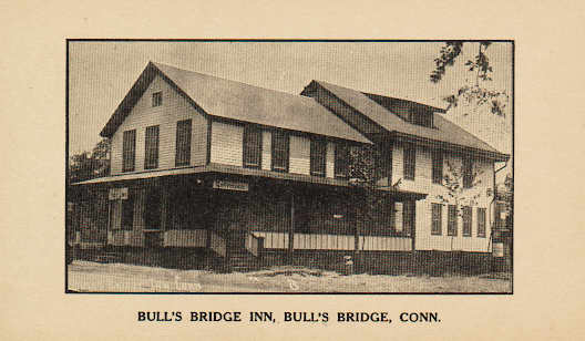 In 1991, Hank Zaccara purchased the Bull's Bridge Inn. He has owned Chuck's Steak House in Danbury, Connecticut, since its opening in 1972 and has built the business into a multi-million dollar a year landmark establishment in Western Connecticut. Chuck's has served nearly a thousand dinners on Friday and Saturday nights in peak seasons on a regular basis with a thriving bar and lounge business ever since.
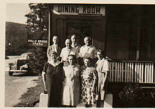
 For the initial opening, Mr. Zaccara brought his family and key members of his staff to Kent to establish the Bull's Bridge Inn and hired local contractors and residents to form his new staff, many of whom still remain to this day. Following extensive renovations and improvements to the building while retaining the original look and feel of the old building, the new incarnation of The Bull's Bridge Inn opened a few months after the purchase with a classic American menu and live entertainment.
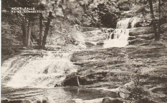
 The restaurant also provided a base for rafters and kayakers on the Housatonic, hikers on the Appalachian Trail and travelers and commuters on Route 7 (Kent Road). The restaurant is located at the Bull's Bridge Dam, home of the storied Bull's Bridge hydro-electric facility built in 1903. The dam is at the head of the Bull's Bridge Gorge, which features Level 5 rated rapids for rafters and kayakers and is a highly dangerous stretch of the Housatonic, designated so for experts only during peak water-flow periods during the year.
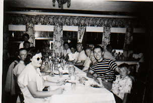
 The Bull's Bridge Inn has remained consistent in the years since Mr. Zaccara took over, changing with the times while always maintaining the intimate, familiar charm and friendly spirit that has made it a staple in the community for well over 200 years. The restaurant quickly developed a loyal and regular following with consistent quality and service, also playing host to numerous weddings and special occasions, creating memories for many to last a lifetime.
 Mr. Zaccara's son, Tom, has been the general manager, executive chef and constant presence at the restaurant since he and his father opened. Tom is a graduate of The College of Culinary Arts at Johnson & Wales University and has honed his craft in fine dining establishments throughout the United States. He continues to experiment with specials on the Bull's Bridge menu on a constantly revolving basis including cuisines from around the world.
 Reservations are not necessary although recommended at the Bull's Bridge Inn. The atmosphere is casual, and whether patrons are looking for a quiet, romantic setting, have dinner at the bar, or reserve a private section for a group gathering, the Bull's Bridge Inn can spell the perfect destination for a night out with family, friends or a couple on their first date.
About Bull's Bridge Hydroelectric Plant
 In the spring of 1903, the New Milford Power Company was approaching the completion of the first commercially viable hydroelectric power plant on the Housatonic River in Connecticut.
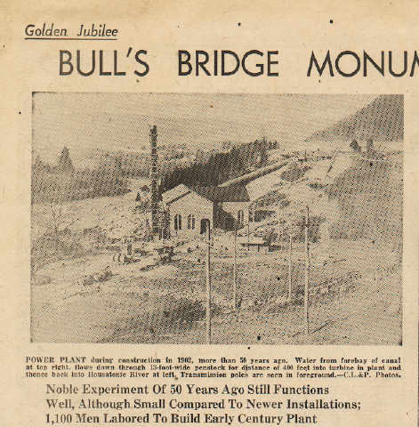
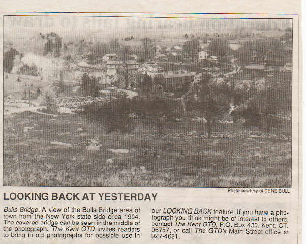
The project, known at the time as the Bull's Bridge Development, broke ground in spring 1902 and water began flowing through the head gate of the plant in 1903. Bull's Bridge was named after the Bull family that had lived in the area for generations.
In the spring of 1903, the New Milford Power Company was approaching the completion of the first commercially viable hydroelectric power plant on the Housatonic River in Connecticut.
The project, known at the time as the Bull's Bridge Development, broke ground in spring 1902 and water began flowing through the head gate of the plant in 1903. Bull's Bridge was named after the Bull family that had lived in the area for generations.
A 1903 newspaper clip from the Amenia Times announced the coming attraction:
The story that capitalists are to develop the water power of the Housatonic River is again in circulation. It is to the effect that the company has a capital of one million dollars to build a dam at Kent Furnace and another at Falls Village. The same company at Bull's Bridge is constructing a dam two hundred feet long and twenty feet high. The water is to be taken through a canal a distance of two miles where is will generate electricity of seven thousand horse-power.
The world’s first hydroelectric station built for widespread commercial use went into operation in Appleton, Wisconsin in September 1882. Inspired by Thomas Edison’s plans for an electricity-producing station in New York, paper manufacturer H.F. Rogers purchased the rights for an Edison-designed central station and the Appleton Edison Electric Company was born.
The first hydroelectric plant in New England was built on the Farmington River in 1889 and it carried power to Hartford over aluminum wire transmission lines. This and the Bull's Bridge plant were relatively small-scale, experimental facilities compared to the first large-scale hydroelectric plant built in 1893 at Niagara Falls.
At the January 1893 session of the General Assembly, the New Milford Power Company was granted “power to acquire all such land and real estate as may be necessary or convenient with the use of water power upon the Housatonic River, at or near Bull's Falls, Gaylord Bridge and Lover’s Leap.”
The company had its charter and within a few years, former Connecticut State Senator, Comptroller and New Milford resident Nicholas Staub, with help from Issac B. Bristol, purchased controlling interests in the land needed for the Bull's Bridge Development.
In 1900, Walter Scott Morton, who would become chief engineer and director of the project, with financial assistance from Robert N. King, Joseph W. Ogden and Charles Sooysmith, purchased New Milford Power, in addition to controlling interest of the rights to power at Fall’s Village.
The head-waters that would be harnessed by the dam at its present location were considered to be insufficient for commercial development at the time so a plan was devised to build a canal to the east, using the additional drop of the river over the next two miles and bypassing its many turns. A total head (high point of the water) of 115 feet was theorized where the water would come back down a hill to the river, two miles below, and the plan was official. Mr. Morton, using “Kutter’s Formula,” designed the hydraulic gradient slopes for the project.
In the spring of 1902, surveying and engineering began at Bull's Bridge, and later that year, teams of Italian laborers began the daunting task of digging the canal. Records show that there were 500 to 1,000 Italian immigrants at work on the project during its various stages. Sources also report there were many Irish immigrants working on the project, as well as a few Schaghticoke Indians.
Teams of 20 to 30 men were formed, each with a foreman, and they lived in crude shanties along Route 7 near the canal.
Not much is known of the impact of the workers on the area but an additional 1,000 men must have made some noise in Kent and surrounding towns, not to mention causing a drain of supplies and services.
In a 1976 interview from the “Northeast Utilities Scope,” a company publication, Earle Henderson, an employee, recalled that his grandfather, a New Milford farmer, hired out teams of horses to contractors involved in the Bull's Bridge Development. Mr. Henderson remembered hearing that “it was the talk of the farming communities of New Milford and Kent.”
One of the most amazing aspects of the project at the time was the plant’s distance from the intended destination of the power produced: Waterbury was 26 miles and 2,600 utility poles away. The New Milford Power Company had a supply contract with the Connecticut Railway and Lighting Company, on Freight Street in Waterbury, to furnish power for its trolleys and the growing number of homes with electricity in that area.
Kent and New Milford residents had mixed feelings about the grand project commencing near their homes, according to town meetings from that time period. However, the scope of such a project had never been witnessed in the area before and the novelty of it won many supporters.
 The Canal
The entrance to the canal begins just east of the main dam, a few yards from Route 7, fronted by an old rope bridge floating on the water, leading to the shore. For the next six hundred feet south, the entrance of the canal flows between two 20-foot high walls of rock before arriving at the gatehouse, which gauges the flow into the canal and sends what is not used back into the river over another concrete dam.
As much as Northeast Utilities fences the area off from curious onlookers, when the water is low, all areas can be reached by foot for observation but the loose stone, dirt walls and slick concrete make for dangerous footing next to the swiftly moving water in the canal. The gatehouse is about half the size it was 100 years ago but the rest of this area is virtually unchanged.
From the gatehouse, the canal extends two miles south to provide the thrust of water to generate electricity at the power plant below the sharp bend on Route 7, just south of the New Milford (Gaylordsville) line, with the “head gatehouse” overlooking the road and pen stocks below it.
One third of the canal had to be blasted out of solid rock, one of the most time-consuming tasks during construction of the project. Once the earth and rock was loosened, excavation went as planned and the material was shipped away or used for fill further down the canal. Guy derricks with 40 and 45-foot booms and double drum steam hoists were used for the heavy lifting.
Steam drills were also used to break up rock but the work was grueling and the most modern tools that most of the men had were sledgehammers and shovels.
The canal extends from the first gatehouse for about 1,000 feet to Cemetery Pond. From there south to the head gate, the base is primarily earth with some ledge.
The canal held for a few years until leaks started appearing. In 1941 it was drained and most of it was lined with gunite – a mixture of Portland cement and sand thoroughly mixed dry – a material now used in swimming pools. In subsequent years each of the dams and the surface areas below them were also covered with gunite.
 Construction
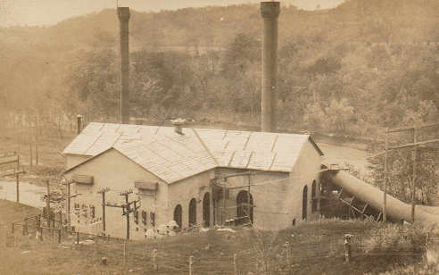
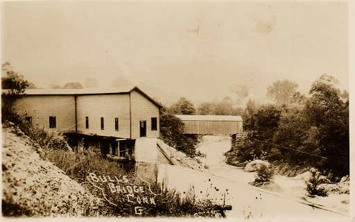
Construction of the main dam, or horseshoe dam, was begun after a cofferdam – made of brush loaded down with heavy stones – was built north of it to hold the river back. Much of the water was diverted to the old flood plain to the west, over what is now the Spooner Dam, and back into the river just below the covered bridge. The rest was diverted through the newly built canal and drained back into the river on the other side of the covered bridge.
The horseshoe dam was built of Portland cement and rocks, some weighing as much as 5,000 pounds.
“It looked like Lincoln Logs stacked up and they filled it full of rock for ballast,” said Bob Gates (in March, 2003), the station manager of Connecticut Hydro for Northeast Generation. “When they were done with that they would pour concrete up against it and over the top as the wearing surface to keep it tight.”
The crest of the dam is made of one-part cement, one-and-a-half parts sand and one-and-a-half parts screened pebbles for a strong wearing surface. It is 200 feet long at the top and 20 feet high from the bedrock. Crest elevation is 352 feet above sea level.
The dam created a reservoir in which the upper three feet provided about 500 cubic-feet-per-second of water for 10 hours on top of the normal flow of the river. The spillway section – adjoining the first gatehouse – is made of Portland cement mortar, and that dam is 19 feet high, from ledge to crest, and 142 feet long. The gate collects debris and the water is returned to the natural flow of the river.
Spooner Dam was built at about the same time because the water backed up by the horseshoe dam would have created another gorge to the west, nullifying some of the power potential.
“It was a low spot in the river and they were trying to build as much storage as possible based on the topography at the time,” Mr. Gates said. “It would bypass our generators if we didn’t impound in both locations.”
Spooner Dam is a weir dam – sometimes called a low dam – built to regulate or measure the flow of diverted water. It still has moveable wooden flash boards on top to control the flow of water, which can bring the crest to the same level as the crest of the horseshoe dam. The dam was built with rock fill and multiple layers of concrete walls and is 14.4 feet tall and 130 feet wide.
 The Head Gate and Power Plant
Steel trash racks 22 by 60 feet long are mounted in front of the head gate (house) to decrease entrance losses at the end of the canal. Passersby on Route 7 can still see workers dragging piles of branches and other debris away from the yellow head gatehouse at the sharp bend in the road.
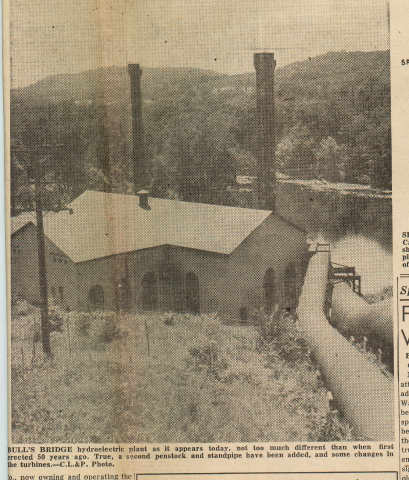
Originally, just one 12-foot diameter steel pen stock was built from the head gate to the power plant below, but a second, eight-foot pen stock was installed in 1912 when the waterwheel units overheated because of a lack of water to feed them. The additional pipe increased the output to 8,000 kilowatts.
The main pipe at the waterwheels gets smaller and smaller as it passes each one. It then passes into the turbine barrel, through the turbines, down into the draft tubes and into the river. The draft tube creates more suction into the system by assuring that no significant air gaps get in.
The two, 100-foot surge towers – now a Route 7 landmark – are in place to handle the “water hammer effect” when the system closes. If it weren’t for the towers, the sudden back up of water would eventually compromise the seams of the pen stocks and other equipment. The towers top out at the same height as the crest of the horseshoe dam. Passersby who time it right can still see water spurt out of the top of the towers when the generators are turned off.
The powerhouse is built entirely of concrete, 48 by 115 feet, and filled with the wheels, hydraulic valves, generators and exciters. Another room to the east contains the switchboard, oil gauges, electrical connections, transformers and lightning arresters. The electrical equipment inside the station looks virtually the same today as it did when it was built.
According to Northeast Generation, the depth of the Housatonic River at the outlet of the powerhouse is about 15 feet deep although some kayakers and river enthusiasts claim it is much deeper.
Bull's Bridge Power Plant has an 8.4 megawatt capacity (8,400 watts) and produces 45 million kilowatt hours per year. A kilowatt hour is produced after generating for an hour. When the plant was built, the capacity was 6,000 kilowatts and the double-pole transmission lines operated at 33,500 volts. Northeast Generation does not store the power, it merely holds back water as power and current is created when the water flows through.
Early on, the Connecticut Light and Power Company’s (CL&P) engineers knew they needed to increase the hydro capacity of the Housatonic, so in 1926 they began flooding what would become Candlewood Lake and built the Rocky River station in New Milford, the first large-scale pumped-storage development in the United States.
The Bull's Bridge Power Plant is part of a five-station hydro operation on the Housatonic, which includes the Falls Village plant in Canaan (10.5 megawatts), built in 1905, the Stevenson plant in Monroe (28-megawatts [1919]), the Shepaug plant in Southbury (47-megawatts [1955]) and the Rocky River plant (31-megawatts [1928]).
 The New Milford Power Company sold all franchises to the Housatonic Power Company in 1915. On August 9, 1917, it sold all franchises to the Rocky River Power Company, which, on the same date, changed its name to the Connecticut Light and Power Company. John Henry Roraback of Canaan, a lawyer and chairman of the Connecticut Republican Party for many years, was the new company’s founder. He was president of CL&P from 1925 until his death in 1937.
On December 10, 1904, a town meeting was held in Kent to amend Section 7 of the charter of the New Milford Power Company, putting the burden on the company for future work caused by the project.
“It shall be the duty of said corporation to forever maintain and keep said bridges in repair,” read the amendment, which carried unanimously. “This amendment shall apply and relate to all roads or highways that may here-after be changed, and any bridge.”
In 1998 the Schaghticoke Tribal Nation filed a lawsuit to reclaim 2,000 acres of land it claims was taken from it in illegal transactions by former overseers including approximately 48 acres of CL&P’s land – most of which is the narrow strip between the river and Schaghticoke Road on the west side of the Housatonic in Kent. Part of that includes a few acres along the road that was the burial grounds for the tribe, which was flooded when the main dam was completed.
For many casual observers strolling around the Bull's Bridge area, the thought of the undertaking of such a project is stunning considering the topography and the seemingly uncontrollable force of the water that flows through the Bull's Bridge Gorge (class IV and V rapids) during the spring freshet and seasonal floods.
The gorge and the river below is a magnet for experienced kayakers year-round. The fair-weather sportsmen will opt for the calmer conditions but experts can be seen throughout the winter and spring in the worst (or best) conditions imaginable.
The New Milford Power Company sold all franchises to the Housatonic Power Company in 1915. On August 9, 1917, it sold all franchises to the Rocky River Power Company, which, on the same date, changed its name to the Connecticut Light and Power Company. John Henry Roraback of Canaan, a lawyer and chairman of the Connecticut Republican Party for many years, was the new company’s founder. He was president of CL&P from 1925 until his death in 1937.
On December 10, 1904, a town meeting was held in Kent to amend Section 7 of the charter of the New Milford Power Company, putting the burden on the company for future work caused by the project.
“It shall be the duty of said corporation to forever maintain and keep said bridges in repair,” read the amendment, which carried unanimously. “This amendment shall apply and relate to all roads or highways that may here-after be changed, and any bridge.”
In 1998 the Schaghticoke Tribal Nation filed a lawsuit to reclaim 2,000 acres of land it claims was taken from it in illegal transactions by former overseers including approximately 48 acres of CL&P’s land – most of which is the narrow strip between the river and Schaghticoke Road on the west side of the Housatonic in Kent. Part of that includes a few acres along the road that was the burial grounds for the tribe, which was flooded when the main dam was completed.
For many casual observers strolling around the Bull's Bridge area, the thought of the undertaking of such a project is stunning considering the topography and the seemingly uncontrollable force of the water that flows through the Bull's Bridge Gorge (class IV and V rapids) during the spring freshet and seasonal floods.
The gorge and the river below is a magnet for experienced kayakers year-round. The fair-weather sportsmen will opt for the calmer conditions but experts can be seen throughout the winter and spring in the worst (or best) conditions imaginable.
 Hikers, runners and sightseers are free to roam nearly all of the Northeast Utilities/CL&P land that encompasses the Bull's Bridge project, and the area is kept in impeccable condition. The Appalachian Trail parallels the Housatonic River on the west side while lookout areas and parking are provided near the covered bridge. The Bull's Bridge Inn is a short walk away, providing a hub for hikers, fishermen, boaters and tourists alike.
Northeast Generation, a subsidiary of Northeast Utilities, will celebrate 100 years of hydroelectric power next year, the anniversary of the first cranking of the generators.
Hikers, runners and sightseers are free to roam nearly all of the Northeast Utilities/CL&P land that encompasses the Bull's Bridge project, and the area is kept in impeccable condition. The Appalachian Trail parallels the Housatonic River on the west side while lookout areas and parking are provided near the covered bridge. The Bull's Bridge Inn is a short walk away, providing a hub for hikers, fishermen, boaters and tourists alike.
Northeast Generation, a subsidiary of Northeast Utilities, will celebrate 100 years of hydroelectric power next year, the anniversary of the first cranking of the generators.
 The following clip from the Amenia Times describes the Bull's Bridge Development shortly before the canal was filled with water for the first time in 1903:
The work at Bull’s Bridge, which for the past year and more has employed from ten to twelve hundred hands, is rapidly approaching completion. The permanent dam now spans the river from shore to shore. The canal is cemented the entire length, and in due time the power house will be equipped for operation, and electric light from Bull’s Bridge, forced by the mighty power of the old Housatonic River, will shine forth in towns and cities throughout the land.
The following clip from the Amenia Times describes the Bull's Bridge Development shortly before the canal was filled with water for the first time in 1903:
The work at Bull’s Bridge, which for the past year and more has employed from ten to twelve hundred hands, is rapidly approaching completion. The permanent dam now spans the river from shore to shore. The canal is cemented the entire length, and in due time the power house will be equipped for operation, and electric light from Bull’s Bridge, forced by the mighty power of the old Housatonic River, will shine forth in towns and cities throughout the land.